Scattered Storms and High Humidity: A Gray Friday for the Magic City
A Day of Atmospheric Drama
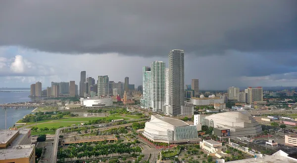
As Miami kicks off the weekend this Friday, March 13, 2026, the city finds itself caught in a period of significant weather whiplash. While a powerful polar vortex and 'soul-crushing' Arctic chill descend upon the Midwest and Northeast, South Florida is facing a much different—though equally active—set of conditions. Today, Miamians can expect a muggy, unsettled atmosphere characterized by scattered thunderstorms and stubborn humidity that will keep the air feeling heavy throughout the day.
Morning: A Warm and Muggy Start
The day began with a late sunrise at 7:34 AM, revealing a sky already thick with cloud cover. Early morning commuters likely noticed the intense humidity levels, which reached as high as 87% at the break of dawn. Temperatures started in the low 70s, quickly rising toward a morning average of 73°F. Despite the early gloom, the chance of precipitation remains relatively moderate during the first few hours of the day, though the 'muggy' factor remains high due to dew points sitting in the high 60s.
Afternoon: Thunderstorms and Peak Heat
By the time the sun reaches its highest point at 1:31 PM, the risk for scattered thunderstorms will peak. Forecasts indicate a 35% chance of rain during the afternoon hours, with the potential for localized heavy downpours that could impact the afternoon rush hour. The high temperature for today is expected to top out at 78°F, though the combination of high humidity and light winds will make it feel closer to 82°F. Unlike the freezing conditions currently walloping the rest of the East Coast, Miami remains firmly in the 'warm and stormy' category of this national weather event.
Evening: Sunset and Clearing Skies
As we head toward a 7:29 PM sunset, the atmospheric pressure is expected to stabilize slightly. The chance of rain drops significantly after dark to about 15%, leading to a clearer but still humid night. Evening temperatures will settle into a comfortable range, with a projected low between 71°F and 72°F. For those planning outdoor activities tonight, the 'blue hour' following sunset should offer a brief reprieve from the afternoon’s storm activity, though periodic clouds will likely linger until the late hours.
Marine Warnings and Safety Advisories
While conditions on land remain manageable with an umbrella, the coastal situation is more precarious. The National Hurricane Center and local authorities have confirmed that marine warnings are currently in effect for the Atlantic and Southwest North Atlantic waters. While there are no tropical cyclones currently threatening the region, the active jet stream is producing hazardous conditions for small craft. Boaters and beachgoers should remain vigilant, especially given the history of sudden waterspouts in the area during active March weather patterns.