South Florida temperatures climb as weekend humidity increases scattered storms and localized downpours across the region
Warming trend coincides with higher humidity and an uptick in weekend storm chances
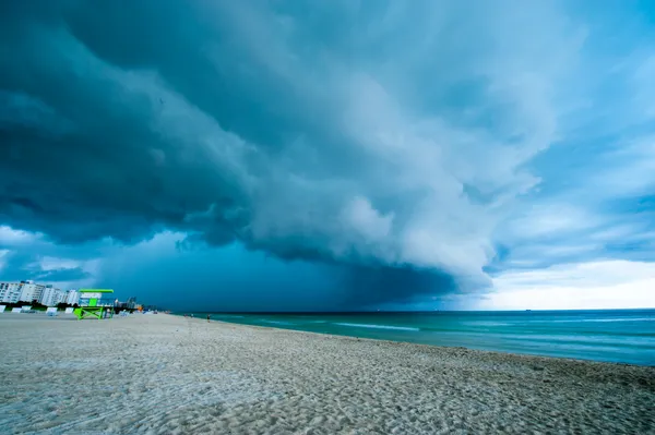
South Florida is heading into the weekend with rising temperatures and increasing humidity, a combination expected to boost the likelihood of afternoon showers and thunderstorms across Miami-Dade, Broward and Palm Beach counties. Highs are forecast to reach the mid-80s on Friday, with similarly warm conditions continuing into Saturday and Sunday as moisture returns to the region.
The pattern reflects a broader setup in the Southeast U.S., where a frontal boundary moving toward the Florida peninsula is expected to provide enough lift and instability for scattered convection. While the region is not forecast to face an organized, all-day rain event, the daily chance of storms is expected to be higher than what many communities have experienced in recent weeks.
What to expect: hit-or-miss storms with pockets of heavier rain
The highest likelihood of storms is expected during the afternoon and early evening hours on both Saturday and Sunday, when daytime heating is strongest. Storm coverage is expected to be uneven, meaning some neighborhoods could see little to no rain while others receive brief but intense downpours.
- Storms may produce frequent lightning and brief gusty winds.
- Rainfall totals are expected to vary sharply over short distances.
- Localized downpours could lead to brief ponding in poor-drainage areas.
Inland areas typically see higher storm coverage in these setups, particularly where boundaries such as sea breezes and outflow lines collide. As a result, the most consistent storm development is expected away from the immediate coast, although any location can be affected.
Rain offers limited relief as drought and wildfire concerns persist
The return of rain chances comes as much of Florida remains in drought, with severe to extreme conditions affecting large parts of the state. Recent dryness has heightened wildfire risk, and an ongoing wildfire in the Big Cypress area has burned tens of thousands of acres in late February, periodically affecting visibility and travel corridors with smoke.
Even where weekend storms deliver meaningful rainfall, forecasters caution that short-lived, uneven precipitation typically does not resolve long-term deficits. Drought recovery generally requires repeated, widespread rainfall over an extended period, rather than isolated thunderstorms that can miss large areas entirely.
Early next week: showers remain possible, but no clear end to dryness yet
Looking beyond the weekend, at least modest rain chances are expected to continue into next week, with the potential for occasional showers moving in from the Atlantic. Temperatures are expected to remain seasonably warm, though day-to-day rain coverage will depend on the exact placement of lingering boundaries and the depth of available moisture.
Residents should plan for changing conditions during the afternoon hours this weekend, including lightning risk and brief heavy rain that can develop quickly and vary widely from one neighborhood to the next.